
South Lismore Flood Mitigation Works
This project is now complete.
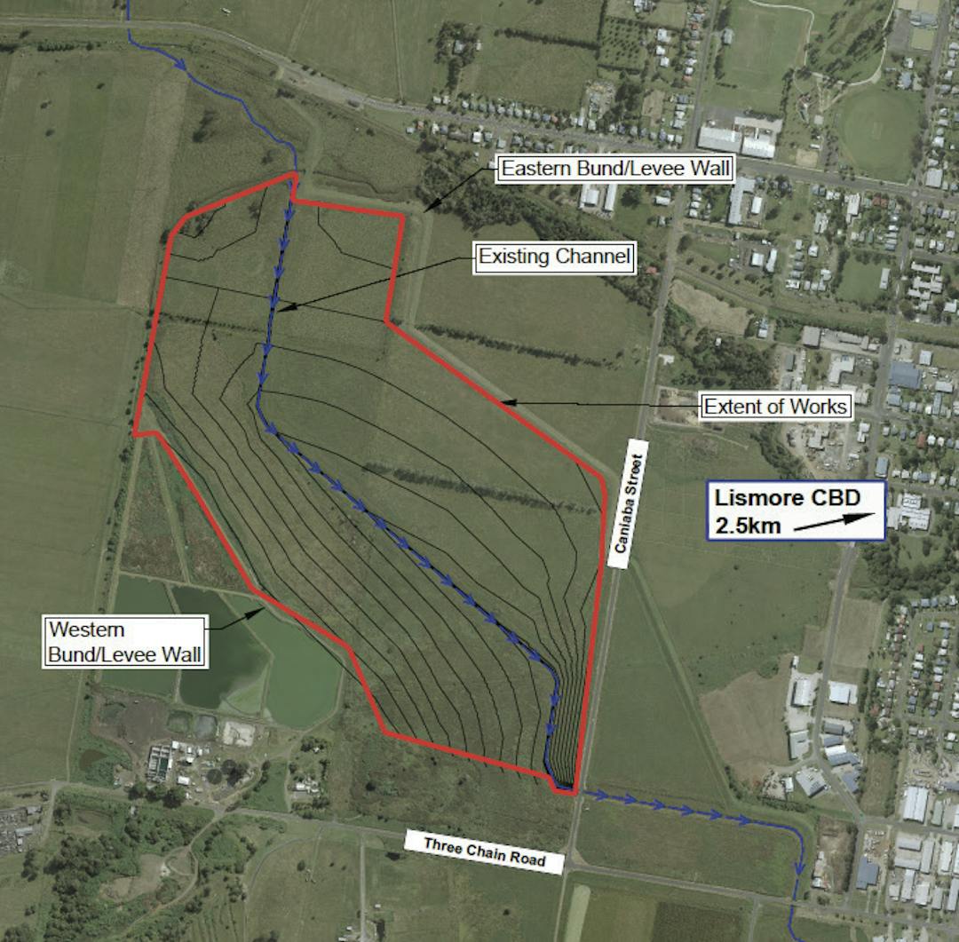
The South Lismore Flood Mitigation Works project involves excavating a large amount of material from the Lismore floodplain to reduce flood water levels in the CBD, North Lismore and South Lismore. Work commenced in October 2019 and is expected to take 12 months.
About the project
The project, which is funded by an $8.2 million grant from the NSW Government, involves removing 410,000m³ of soil from a 58-hectare area of land owned by Council. The land is located behind the Lismore Regional Airport and is adjacent to Caniaba Street - please see map here for more information. The dirt removed will be used to fill nearby industrial land.
What will the benefit be?
Flood modelling (Worley Parsons, 2016) suggests this project will reduce peak water levels in the CBD, North Lismore and South Lismore by as much as 100mm in a 1-in-100-year flood event. For more information please read the full report here.
By using the material from the excavation site to fill industrial land within Lismore's floodplain, we will facilitate the expansion of the South Lismore Industrial Estate and help drive economic growth in Lismore.
How to keep updated?
We will keep this page updated as the project progresses. If you would like to receive updates directly to your email, please register for Your Say Lismore.
If you have any questions, please ask them below. We will respond to them as quickly as possible.
This project is now complete.
If you have any questions about the South Lismore Flood Mitigation Works
-
Share Dear Mr.Hoffman, It would be nice if you could answer me the two following questions: 1. Is the street we live in (Macaulay Street) included in the study? 2.Where can I find the map for the (already approved) areas which will be (or are already) land filled and are included in the study (and their amounts/heights) ? Thank you for your time. Kind regards, Viola on Facebook Share Dear Mr.Hoffman, It would be nice if you could answer me the two following questions: 1. Is the street we live in (Macaulay Street) included in the study? 2.Where can I find the map for the (already approved) areas which will be (or are already) land filled and are included in the study (and their amounts/heights) ? Thank you for your time. Kind regards, Viola on Twitter Share Dear Mr.Hoffman, It would be nice if you could answer me the two following questions: 1. Is the street we live in (Macaulay Street) included in the study? 2.Where can I find the map for the (already approved) areas which will be (or are already) land filled and are included in the study (and their amounts/heights) ? Thank you for your time. Kind regards, Viola on Linkedin Email Dear Mr.Hoffman, It would be nice if you could answer me the two following questions: 1. Is the street we live in (Macaulay Street) included in the study? 2.Where can I find the map for the (already approved) areas which will be (or are already) land filled and are included in the study (and their amounts/heights) ? Thank you for your time. Kind regards, Viola link
Dear Mr.Hoffman, It would be nice if you could answer me the two following questions: 1. Is the street we live in (Macaulay Street) included in the study? 2.Where can I find the map for the (already approved) areas which will be (or are already) land filled and are included in the study (and their amounts/heights) ? Thank you for your time. Kind regards, Viola
Viola asked about 5 years agoHello Viola,
Yes, Macauly Street is included in the study – refer to figure 9 on page 17 in the Worley Parsons Report (link under the ‘What will the benefits be?’ section).
On the same figure, the land approved for filling shows up as bright green (e.g the lots around the airport). Sections 4.3 and 4.4. of the report shows the land approved for filling.
If you want to discuss the specifics of any of these developments further, we are happy to give you a call. We are wondering what amounts/heights exactly you are referring to? Is there a particular development you want to know this information for?
Please contact the Community Engagement Team on 1300 87 83 87 to discuss or email engagement@lismore.nsw.gov.au.
Thank you,
Aaron Hoffman - Project Manager
-
Share Tell us where this diverted floodwater is going to go once it joins the tidal Wilson River just downstream from Lismore ? The hydraulic analysis of the effects of the proposed floodway excavation shows that once complete, there would be a reduction in river level of approximately 100mm at the rowing club gauge for a 1 in 100 year flood event. This is not an answer, please re answer specifically on Facebook Share Tell us where this diverted floodwater is going to go once it joins the tidal Wilson River just downstream from Lismore ? The hydraulic analysis of the effects of the proposed floodway excavation shows that once complete, there would be a reduction in river level of approximately 100mm at the rowing club gauge for a 1 in 100 year flood event. This is not an answer, please re answer specifically on Twitter Share Tell us where this diverted floodwater is going to go once it joins the tidal Wilson River just downstream from Lismore ? The hydraulic analysis of the effects of the proposed floodway excavation shows that once complete, there would be a reduction in river level of approximately 100mm at the rowing club gauge for a 1 in 100 year flood event. This is not an answer, please re answer specifically on Linkedin Email Tell us where this diverted floodwater is going to go once it joins the tidal Wilson River just downstream from Lismore ? The hydraulic analysis of the effects of the proposed floodway excavation shows that once complete, there would be a reduction in river level of approximately 100mm at the rowing club gauge for a 1 in 100 year flood event. This is not an answer, please re answer specifically link
Tell us where this diverted floodwater is going to go once it joins the tidal Wilson River just downstream from Lismore ? The hydraulic analysis of the effects of the proposed floodway excavation shows that once complete, there would be a reduction in river level of approximately 100mm at the rowing club gauge for a 1 in 100 year flood event. This is not an answer, please re answer specifically
Darren Williams asked about 6 years agoHi Darren,
Thanks for your question. The water will join the rest of the Wilsons River as it flows downstream out toward Coraki and eventually on to Ballina. Having a deeper channel in this location means that more floodwater can flow south and join the Wilsons River, reducing levels to the north. The channel simply means that a greater volume of floodwater will be concentrated in this area instead of across the floodplain.
As the project is occurring within the exiting floodplain, the water isn’t diverted as such. The benefits are realised by essentially recontouring the river bed (remembering that the entire floodplain becomes the river bed in a flood) which the modelling shows results in a drop in flood levels in the CBD, North Lismore and South Lismore and no change once downstream as far as the airport. The floodwater essentially continues downstream (as it always has) and because the same volume of water will meet the same point in the river (albeit by a slightly different way as a result of the project), the net result is 0 – this is shown in the report by Worley Parsons found in the Document Library on the project page (refer figure 9).
Hope this is clear Darren and happy to discuss further in person if you wish. You can call me on 1300 87 83 87.
Regards,
Aaron Hoffman – Project Manager
-
Share When the Wilson's level rises by many metres during times of excessive rain, what value is there in reducing the level by 100mm? Also, the river is tidal> Wouldn't the diverted water be forced back into the city on the occasion of a high tide? on Facebook Share When the Wilson's level rises by many metres during times of excessive rain, what value is there in reducing the level by 100mm? Also, the river is tidal> Wouldn't the diverted water be forced back into the city on the occasion of a high tide? on Twitter Share When the Wilson's level rises by many metres during times of excessive rain, what value is there in reducing the level by 100mm? Also, the river is tidal> Wouldn't the diverted water be forced back into the city on the occasion of a high tide? on Linkedin Email When the Wilson's level rises by many metres during times of excessive rain, what value is there in reducing the level by 100mm? Also, the river is tidal> Wouldn't the diverted water be forced back into the city on the occasion of a high tide? link
When the Wilson's level rises by many metres during times of excessive rain, what value is there in reducing the level by 100mm? Also, the river is tidal> Wouldn't the diverted water be forced back into the city on the occasion of a high tide?
RayS asked about 6 years agoHello,
100mm might not seem like much at first glance but it represent an extremely large volume of water when you consider the entire area of the flood plain. 100mm could be the different between a major flood topping the levee or reaching that next shelf of items for a business in the CBD. Furthermore, the immediate flood level reductions are just one benefit of the project. The other is the economic development which will be facilitated by filling industrial zoned land above the 1 in 100 year flood level, allowing new businesses to build and operate.
The comment about tidal movements is valid to the extent that flood levels are higher during a high tide when compared to a low tide however the net benefit is still positive as a result of this project i.e. if the exact same flood was to occur on the exact same tide, pre and post construction, the flood which occurred post construction would have lower water levels in the CBD.
Regards,
Aaron Hoffman - Project Manager
-
Share This effectiveness of this plan is highly questionable. Tell us where this diverted floodwater is going to go once it joins the tidal Wilson River just downstream from Lismore ? Depending on factors such as state of the tide, rainfall in the middle Richmond and South Arm of the Richmond River the water is just as likely to flow in reverse back up towards the CBD as I have seen it do at the junction in Lismore. Water finds its own level and unfortunately there is no magic waterfall south of the CBD for the water to disappear and in fact there is only around one metre in fall in 100 kms of river between Lismore and Ballina during normal, non flood conditions. Why does this plan involve removing the railway infrastructure foundation when the railway which has been there for over 100 years and has floodways built into the embankment to adequately cope with floodwater from Leicester Creek ? Why did LCC claim that during the last flood these railway floodways held back floodwater without mentioning the fact that the largest floodway, now removed at council request, was in fact blocked up with numerous plastic wrapped hay bales from the nearby dairy farm as well as other flood debris? Why hasn't Lismore council requested that John Holland Rail who are paid $750,000 p.a. to maintain vegetation on the corridor , keep all these railway floodways clear of vegetation as a preventative measure so they can function as designed. It was the council who requested of the State Gov, via John Holland Rail that the largest floodway be removed as the flood debris caught there with the hay bales was cited as a health hazard for school children walking by when in fact no school children actually walk past that site. Sounds very much like it was a cooked up plan by a certain Councillor to bolster the case for removing the infrastructure. There are many people on the North Coast who would like to see rail services resumed and despite the current version of LCC who don't support this , they must realise they are only temporary and future councils may hold a very different position to their own having recognised the connectivity and economic benefits for Lismore. on Facebook Share This effectiveness of this plan is highly questionable. Tell us where this diverted floodwater is going to go once it joins the tidal Wilson River just downstream from Lismore ? Depending on factors such as state of the tide, rainfall in the middle Richmond and South Arm of the Richmond River the water is just as likely to flow in reverse back up towards the CBD as I have seen it do at the junction in Lismore. Water finds its own level and unfortunately there is no magic waterfall south of the CBD for the water to disappear and in fact there is only around one metre in fall in 100 kms of river between Lismore and Ballina during normal, non flood conditions. Why does this plan involve removing the railway infrastructure foundation when the railway which has been there for over 100 years and has floodways built into the embankment to adequately cope with floodwater from Leicester Creek ? Why did LCC claim that during the last flood these railway floodways held back floodwater without mentioning the fact that the largest floodway, now removed at council request, was in fact blocked up with numerous plastic wrapped hay bales from the nearby dairy farm as well as other flood debris? Why hasn't Lismore council requested that John Holland Rail who are paid $750,000 p.a. to maintain vegetation on the corridor , keep all these railway floodways clear of vegetation as a preventative measure so they can function as designed. It was the council who requested of the State Gov, via John Holland Rail that the largest floodway be removed as the flood debris caught there with the hay bales was cited as a health hazard for school children walking by when in fact no school children actually walk past that site. Sounds very much like it was a cooked up plan by a certain Councillor to bolster the case for removing the infrastructure. There are many people on the North Coast who would like to see rail services resumed and despite the current version of LCC who don't support this , they must realise they are only temporary and future councils may hold a very different position to their own having recognised the connectivity and economic benefits for Lismore. on Twitter Share This effectiveness of this plan is highly questionable. Tell us where this diverted floodwater is going to go once it joins the tidal Wilson River just downstream from Lismore ? Depending on factors such as state of the tide, rainfall in the middle Richmond and South Arm of the Richmond River the water is just as likely to flow in reverse back up towards the CBD as I have seen it do at the junction in Lismore. Water finds its own level and unfortunately there is no magic waterfall south of the CBD for the water to disappear and in fact there is only around one metre in fall in 100 kms of river between Lismore and Ballina during normal, non flood conditions. Why does this plan involve removing the railway infrastructure foundation when the railway which has been there for over 100 years and has floodways built into the embankment to adequately cope with floodwater from Leicester Creek ? Why did LCC claim that during the last flood these railway floodways held back floodwater without mentioning the fact that the largest floodway, now removed at council request, was in fact blocked up with numerous plastic wrapped hay bales from the nearby dairy farm as well as other flood debris? Why hasn't Lismore council requested that John Holland Rail who are paid $750,000 p.a. to maintain vegetation on the corridor , keep all these railway floodways clear of vegetation as a preventative measure so they can function as designed. It was the council who requested of the State Gov, via John Holland Rail that the largest floodway be removed as the flood debris caught there with the hay bales was cited as a health hazard for school children walking by when in fact no school children actually walk past that site. Sounds very much like it was a cooked up plan by a certain Councillor to bolster the case for removing the infrastructure. There are many people on the North Coast who would like to see rail services resumed and despite the current version of LCC who don't support this , they must realise they are only temporary and future councils may hold a very different position to their own having recognised the connectivity and economic benefits for Lismore. on Linkedin Email This effectiveness of this plan is highly questionable. Tell us where this diverted floodwater is going to go once it joins the tidal Wilson River just downstream from Lismore ? Depending on factors such as state of the tide, rainfall in the middle Richmond and South Arm of the Richmond River the water is just as likely to flow in reverse back up towards the CBD as I have seen it do at the junction in Lismore. Water finds its own level and unfortunately there is no magic waterfall south of the CBD for the water to disappear and in fact there is only around one metre in fall in 100 kms of river between Lismore and Ballina during normal, non flood conditions. Why does this plan involve removing the railway infrastructure foundation when the railway which has been there for over 100 years and has floodways built into the embankment to adequately cope with floodwater from Leicester Creek ? Why did LCC claim that during the last flood these railway floodways held back floodwater without mentioning the fact that the largest floodway, now removed at council request, was in fact blocked up with numerous plastic wrapped hay bales from the nearby dairy farm as well as other flood debris? Why hasn't Lismore council requested that John Holland Rail who are paid $750,000 p.a. to maintain vegetation on the corridor , keep all these railway floodways clear of vegetation as a preventative measure so they can function as designed. It was the council who requested of the State Gov, via John Holland Rail that the largest floodway be removed as the flood debris caught there with the hay bales was cited as a health hazard for school children walking by when in fact no school children actually walk past that site. Sounds very much like it was a cooked up plan by a certain Councillor to bolster the case for removing the infrastructure. There are many people on the North Coast who would like to see rail services resumed and despite the current version of LCC who don't support this , they must realise they are only temporary and future councils may hold a very different position to their own having recognised the connectivity and economic benefits for Lismore. link
This effectiveness of this plan is highly questionable. Tell us where this diverted floodwater is going to go once it joins the tidal Wilson River just downstream from Lismore ? Depending on factors such as state of the tide, rainfall in the middle Richmond and South Arm of the Richmond River the water is just as likely to flow in reverse back up towards the CBD as I have seen it do at the junction in Lismore. Water finds its own level and unfortunately there is no magic waterfall south of the CBD for the water to disappear and in fact there is only around one metre in fall in 100 kms of river between Lismore and Ballina during normal, non flood conditions. Why does this plan involve removing the railway infrastructure foundation when the railway which has been there for over 100 years and has floodways built into the embankment to adequately cope with floodwater from Leicester Creek ? Why did LCC claim that during the last flood these railway floodways held back floodwater without mentioning the fact that the largest floodway, now removed at council request, was in fact blocked up with numerous plastic wrapped hay bales from the nearby dairy farm as well as other flood debris? Why hasn't Lismore council requested that John Holland Rail who are paid $750,000 p.a. to maintain vegetation on the corridor , keep all these railway floodways clear of vegetation as a preventative measure so they can function as designed. It was the council who requested of the State Gov, via John Holland Rail that the largest floodway be removed as the flood debris caught there with the hay bales was cited as a health hazard for school children walking by when in fact no school children actually walk past that site. Sounds very much like it was a cooked up plan by a certain Councillor to bolster the case for removing the infrastructure. There are many people on the North Coast who would like to see rail services resumed and despite the current version of LCC who don't support this , they must realise they are only temporary and future councils may hold a very different position to their own having recognised the connectivity and economic benefits for Lismore.
John Sheldon asked about 6 years agoHi John,
Thank you for your questions and feedback in regards to this project. I have included responses to some of your questions below and passed your feedback to our Assets Manager.
1. Tell us where this diverted floodwater is going to go once it joins the tidal Wilson River just downstream from Lismore ?
The hydraulic analysis of the effects of the proposed floodway excavation shows that once complete, there would be a reduction in river level of approximately 100mm at the rowing club gauge for a 1 in 100 year flood event.
2. Why does this plan involve removing the railway infrastructure foundation when the railway which has been there for over 100 years and has floodways built into the embankment to adequately cope with floodwater from Leicester Creek
The current project does not involve removing any of the railway infrastructure along Kyogle Road/Casino Street. Any decisions on the future of that infrastructure will be made as part of a separate process.
3. Why did LCC claim that during the last flood these railway floodways held back floodwater without mentioning the fact that the largest floodway, now removed at council request, was in fact blocked up with numerous plastic wrapped hay bales from the nearby dairy farm as well as other flood debris?
The design of the aqueduct in this location does have relatively closely spaced columns and footings. Hay bales and other debris did become lodged in the railway aqueduct, causing water to back up and flow in a different direction to what would normally be expected. Any future consideration that may involve removal of this infrastructure could include an analysis of a different structural solution for the railway line with wider spacings for the footings and columns to reduce the risk of blockages during future flood events. However, that exercise is not part of the current project as stated earlier and Council reiterates that none of this infrastructure is to be removed during the current project.
Kind regards,Flora Zigterman,Community Engagement Officer, Lismore City Council
-
Share please tell us what company was awarded the contract? Are you local or from an other area? thank you on Facebook Share please tell us what company was awarded the contract? Are you local or from an other area? thank you on Twitter Share please tell us what company was awarded the contract? Are you local or from an other area? thank you on Linkedin Email please tell us what company was awarded the contract? Are you local or from an other area? thank you link
please tell us what company was awarded the contract? Are you local or from an other area? thank you
jd asked about 6 years agoHi JD,
Thanks for your question. There will be an announcement very soon about the successful contractor. I'll get back to you with this information as soon as possible.
Cheers
Flora Zigterman - Community Engagement Officer, LCC
Hi JD,
Here is the link to our first community update which has information about the contractors who have been appointed to this project.
https://yoursay.lismore.nsw.gov.au/46886/documents/115970
Kind regards,
Flora
-
Share I am happy to hear that the South Lismore Flood Mitigation Works are starting soon Please get on with it without further delay. Another flood could come any day ! I note that on this forum ( and others ) there are several nay-sayers about the project. If we took notice of everyone who has a jab at a positive thing then nothing would get done - ever ! My question is about the Lowering the River Bank to the East of the Bunnings Site Is it possible to take another meter or 2 off this so water gets away from the CBD sooner ? It seems to me that doing this would be really good < bang for the buck > Regards on Facebook Share I am happy to hear that the South Lismore Flood Mitigation Works are starting soon Please get on with it without further delay. Another flood could come any day ! I note that on this forum ( and others ) there are several nay-sayers about the project. If we took notice of everyone who has a jab at a positive thing then nothing would get done - ever ! My question is about the Lowering the River Bank to the East of the Bunnings Site Is it possible to take another meter or 2 off this so water gets away from the CBD sooner ? It seems to me that doing this would be really good < bang for the buck > Regards on Twitter Share I am happy to hear that the South Lismore Flood Mitigation Works are starting soon Please get on with it without further delay. Another flood could come any day ! I note that on this forum ( and others ) there are several nay-sayers about the project. If we took notice of everyone who has a jab at a positive thing then nothing would get done - ever ! My question is about the Lowering the River Bank to the East of the Bunnings Site Is it possible to take another meter or 2 off this so water gets away from the CBD sooner ? It seems to me that doing this would be really good < bang for the buck > Regards on Linkedin Email I am happy to hear that the South Lismore Flood Mitigation Works are starting soon Please get on with it without further delay. Another flood could come any day ! I note that on this forum ( and others ) there are several nay-sayers about the project. If we took notice of everyone who has a jab at a positive thing then nothing would get done - ever ! My question is about the Lowering the River Bank to the East of the Bunnings Site Is it possible to take another meter or 2 off this so water gets away from the CBD sooner ? It seems to me that doing this would be really good < bang for the buck > Regards link
I am happy to hear that the South Lismore Flood Mitigation Works are starting soon Please get on with it without further delay. Another flood could come any day ! I note that on this forum ( and others ) there are several nay-sayers about the project. If we took notice of everyone who has a jab at a positive thing then nothing would get done - ever ! My question is about the Lowering the River Bank to the East of the Bunnings Site Is it possible to take another meter or 2 off this so water gets away from the CBD sooner ? It seems to me that doing this would be really good < bang for the buck > Regards
Ken Gudmundsen asked about 6 years agoHello Ken,
There is a Lismore Floodplain Risk Management committee which comprises of members from Lismore City Council, Rous Country Council, the NSW Office of Environment and Heritage as well as others including community members. One of the rolls of this committee is to look at flood mitigation projects such as this one, and the one your suggested.
If you have a specific request, it would be worth getting in contact with them directly. Some of our Councilors which sit on the committee are: Cr Ekins, Cr Bird, Cr Guise and Cr Marks - their contact details are available on the Lismore City Council web page.
Thanks,
Aaron Hoffman - Project Manager
-
Share When did the tender close? When will the work be allocated to the winning tender? on Facebook Share When did the tender close? When will the work be allocated to the winning tender? on Twitter Share When did the tender close? When will the work be allocated to the winning tender? on Linkedin Email When did the tender close? When will the work be allocated to the winning tender? link
When did the tender close? When will the work be allocated to the winning tender?
Nancy Thomas asked about 6 years agoHello Nancy. The tender closed in August and the contract has subsequently been awarded to SEE Civil. They will be commencing work ASAP; they just need to finalise a number of operational, safety and environmental management plans prior which are required to be approved prior to commencement.
Thanks,
Aaron Hoffman - Project Manager
-
Share Hi, in a previous answer it was mentioned '10cm might not seem like much at first glace but it represent an extremely large volume of water when you consider the entire area of the flood plain. " Can you please quantify the volume of water? Also is it possible to supply a link to the cost benefit analysis of the project please? Thank you. on Facebook Share Hi, in a previous answer it was mentioned '10cm might not seem like much at first glace but it represent an extremely large volume of water when you consider the entire area of the flood plain. " Can you please quantify the volume of water? Also is it possible to supply a link to the cost benefit analysis of the project please? Thank you. on Twitter Share Hi, in a previous answer it was mentioned '10cm might not seem like much at first glace but it represent an extremely large volume of water when you consider the entire area of the flood plain. " Can you please quantify the volume of water? Also is it possible to supply a link to the cost benefit analysis of the project please? Thank you. on Linkedin Email Hi, in a previous answer it was mentioned '10cm might not seem like much at first glace but it represent an extremely large volume of water when you consider the entire area of the flood plain. " Can you please quantify the volume of water? Also is it possible to supply a link to the cost benefit analysis of the project please? Thank you. link
Hi, in a previous answer it was mentioned '10cm might not seem like much at first glace but it represent an extremely large volume of water when you consider the entire area of the flood plain. " Can you please quantify the volume of water? Also is it possible to supply a link to the cost benefit analysis of the project please? Thank you.
Darren Williams asked about 6 years agoHello Darren,
Since Lismore City Council did not conduct the flood modelling assessment in house (a specialist consultant was used), I do not have the data required to quantify the volume of water. By way of compassion, a 1km x 1km area of water that is 100mm (10cm) deep equates to 1 billion litres of water or 400 x Olympic swimming pools.
Regarding the cost benefit analysis, this isn't a public document but the far reaching consequences of flooding in Lismore are well know. For example, the 2017 flood is estimated to of caused more than $40M in damage to businesses alone with as many as 22 closing down in the immediate aftermath resulting in an estimated 51 jobs lost.
Thanks,
Aaron Hoffman - Project Manager
-
Share The most recent flood occurred in Lismore March 2017 whilst this final report is dated 28th January 2016. Has any data from the recent flood been reviewed in conjunction with this report? on Facebook Share The most recent flood occurred in Lismore March 2017 whilst this final report is dated 28th January 2016. Has any data from the recent flood been reviewed in conjunction with this report? on Twitter Share The most recent flood occurred in Lismore March 2017 whilst this final report is dated 28th January 2016. Has any data from the recent flood been reviewed in conjunction with this report? on Linkedin Email The most recent flood occurred in Lismore March 2017 whilst this final report is dated 28th January 2016. Has any data from the recent flood been reviewed in conjunction with this report? link
The most recent flood occurred in Lismore March 2017 whilst this final report is dated 28th January 2016. Has any data from the recent flood been reviewed in conjunction with this report?
Darren Williams asked about 6 years agoRous County Council, who are the Lismore Flood Mitigation Authority are currently calibrating an updated model against the March 2017 flood, which is expected to be completed in the coming months.
The modeling in relation to this project has been regularly conducted and updated over a period of 10 years, showing consistent benefits.
Thanks,
Aaron Hoffman - Project Manager
-
Share Is it true the council is spending $8.2 million on "South Lismore Flood Mitigation Works" project in order to mitigate any future floods by the order of upto 10 cm? Has a cost benefit analysis been completed to support this project? WorleyParsons accepts no liability or responsibility whatsoever for it in respect of any use of or reliance upon this report by any third party. on Facebook Share Is it true the council is spending $8.2 million on "South Lismore Flood Mitigation Works" project in order to mitigate any future floods by the order of upto 10 cm? Has a cost benefit analysis been completed to support this project? WorleyParsons accepts no liability or responsibility whatsoever for it in respect of any use of or reliance upon this report by any third party. on Twitter Share Is it true the council is spending $8.2 million on "South Lismore Flood Mitigation Works" project in order to mitigate any future floods by the order of upto 10 cm? Has a cost benefit analysis been completed to support this project? WorleyParsons accepts no liability or responsibility whatsoever for it in respect of any use of or reliance upon this report by any third party. on Linkedin Email Is it true the council is spending $8.2 million on "South Lismore Flood Mitigation Works" project in order to mitigate any future floods by the order of upto 10 cm? Has a cost benefit analysis been completed to support this project? WorleyParsons accepts no liability or responsibility whatsoever for it in respect of any use of or reliance upon this report by any third party. link
Is it true the council is spending $8.2 million on "South Lismore Flood Mitigation Works" project in order to mitigate any future floods by the order of upto 10 cm? Has a cost benefit analysis been completed to support this project? WorleyParsons accepts no liability or responsibility whatsoever for it in respect of any use of or reliance upon this report by any third party.
Darren Williams asked about 6 years agoHello,
The $8.2 million for the project has come by way of a grant from the NSW State Government. The grant was awarded after submission of a detailed business case which included a cost benefit analysis.
10cm might not seem like much at first glace but it represent an extremely large volume of water when you consider the entire area of the flood plain. 10cm could be the different between a major flood topping the levee or reaching that next shelf of items for a business in the CBD. Furthermore, the immediate flood level reductions are just one benefit of the project. The other is the economic development which will be facilitated by filling industrial zoned land above the 1 in 100 year flood level, allowing new businesses to build an operate. P
The disclaimer by Worley Parsons is very standard for this kind of consulting work / report. Whilst the flood model is calibrated/verified against actual storm events, there are simply too many variables out of their control to offer a blanket guarantee.
Thanks,
Aaron Hoffman - Project Manager
Signup Banner

Life Cycle
-
Tenders Open
South Lismore Flood Mitigation Works has finished this stageNSW Public Works Advisory have issued tenders which close at 9:30am on Tuesday, 6 August 2019.
-
Contract Awarded
South Lismore Flood Mitigation Works has finished this stageContract will be awarded by the end of August 2019.
-
Project Commencement
South Lismore Flood Mitigation Works has finished this stageProject to commence by October 2019.
-
Halfway Milestone
South Lismore Flood Mitigation Works has finished this stageHalfway Milestone is expected to be reached by March 2020.
-
Completion
South Lismore Flood Mitigation Works is currently at this stageProject is expected to be completed by October 2020.
Document Library


Videos
-
Click here to play video South Lismore Flood Mitigation Works - in action
Who's listening
-
Phone 1300 87 83 87 Email Aaron.Hoffman@lismore.nsw.gov.au